
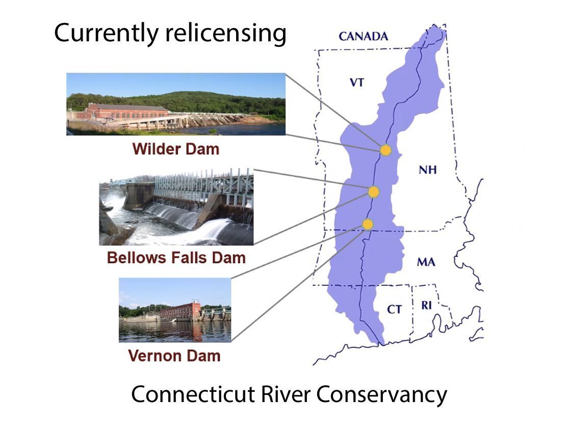
Will Relicensing of Three Hydroelectricity Dams Help With River Bank Collapse and Fish Passage?
The joke among river scientists is that topsoil is the Upper Valley’s biggest export.
Farmers up and down the Connecticut River benefit from some of the finest agricultural soils in the whole of North America. These soils, known as prime agricultural soils, were laid down by millennia of alluvial deposition in the valley bottom. Approximately 221,000 acres of prime soils are currently farmed throughout the watershed. These farms are valuable, both to the region’s identity and for their bountiful supply of vegetables and grains that can only thrive on productive soils.
But all is not well along the river. The construction of hydroelectric dams has raised the water level to the edges of farm fields.
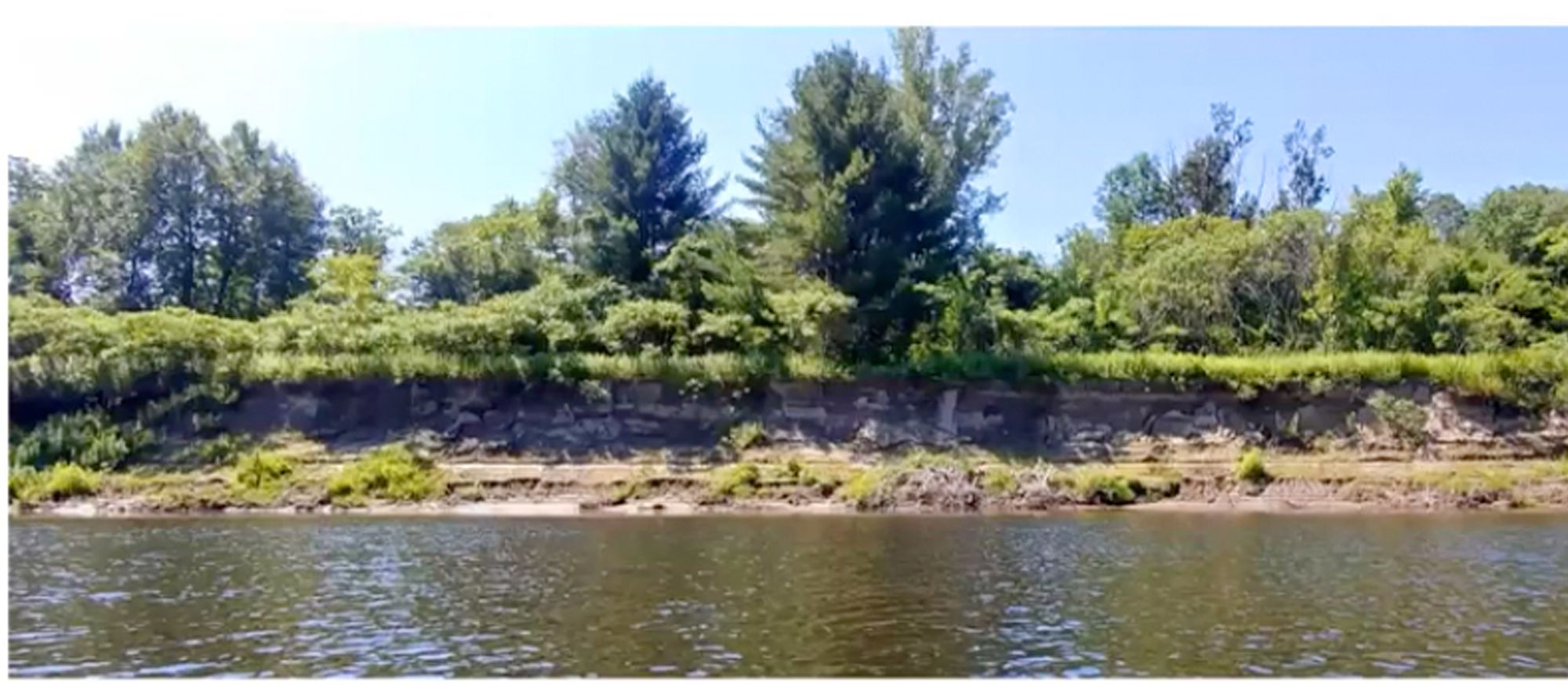
The raised water level “erodes” river banks, or more correctly, causes river bank collapse. Farmers like the Howards of Thetford and Steve Stocking in Fairlee have watched helplessly as acres of precious agricultural soil are whittled away year after year. In 2018, according to an NHPR interview, Stocking estimated he had lost 85 feet of valuable land over the course of 50 years. The Howards have a similar experience. That amounts to a significant reduction in crops and income. The joke among river scientists is that topsoil is the Upper Valley’s biggest export.
Hydro companies assert that their dams do not cause bank “erosion”, which they blame on natural fluctuations in river level. However bank collapse is not the same as bank erosion. To understand how bank collapse happens, we must look at how hydro dams are usually operated. Power companies use “hydropeaking” to take advantage of variations in electricity prices throughout the day. Water is stockpiled behind the dam till about 4:00 pm, when electric rates go up. Water is then released to turn the generator turbines. Flow rates can skyrocket from a trickle to 8,000 cubic feet per second in a matter of minutes, causing a rapid drop in water level. The water release continues, usually till 10:00 pm when electric rates go down Then the flow is shut off and water levels rise again till the next release. Thus the power company maximizes the monetary value of the electricity generated. The water level behind the dam fluctuates on a daily basis by three to five feet.
Bank collapse during times of rapid drawdown is a well documented phenomenon. When the water level is high the river bank soaks up water and becomes waterlogged. However the soggy soil is kept in place by water pressure against it. But when the water level drops suddenly, the soil has no time to drain. The pressure of water moving outwards through the soil is no longer supported, pushing the soil towards the river. The soil structure weakens and eventually cannot hold together and collapses. Rick Howard, whose farm includes a long stretch flanking the Connecticut River in Thetford, commented that over time even trees topple into the river as their roots become destabilized.
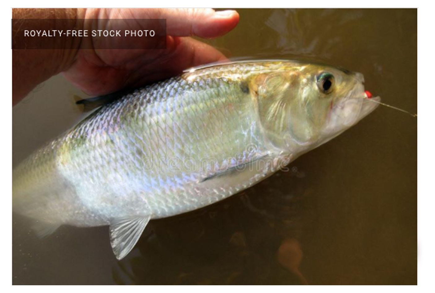
Dams also have many negative impacts on the life inhabiting rivers. Blocking a river with a dam simply stops fish from migrating. Former Connecticut River steward David Deen wrote in 2013 that dams in Massachusetts dating back to 1700 caused the extinction of migratory shad and salmon in the Upper Valley. These fish hatch as tiny lavae in rivers and swim downstream to the ocean where they grow and mature. They migrate up to 12,000 miles before returning to their river of origin to spawn. Shad don’t necessarily die after spawning. Up to 60% of northern shad in the Connecticut River have potential to live and return to spawn several times in their lifetime.
Free-flowing rivers are turbulent and well-oxygenated and sediment does not settle. Dams however, slow down water flow in rivers. Slow-moving water heats up resulting in low oxygen, stagnation, algal blooms and serious decline of the river ecosystem. Sediment drops to the bottom where it clogs the gravel where fish spawn and alters the habitat of species like freshwater mussels. Seventy percent of these mussel species have become extinct over the last 200 years in the US. The impounded lakes behind dams are disorienting to migratory fish because they lack water flow by which fish navigate. Downstream of dams, the abrupt interruptions of water flow leave aquatic species high and dry.
In 2017 a company called Great River Hydro purchased all the dams on the Connecticut River from then owner TransCanada (well-known for the Keystone XL tar sands oil pipeline.) Selling this lucrative asset helped TransCanada finance a $13 billion purchase of Columbia Pipeline Group, making it one of the largest natural gas transmission corporations in North America.
The announcement to sell its hydro assets was made in the middle of negotiations started in 2012 with the Federal Energy Regulatory Commission on the re-licensing of three dams on the Connecticut River: the Wilder, Bellows Falls and Vernon dams.
But who is the owner of the river? The real owner of the nation’s waterways is the public and a river is a Public Trust Resource. The license for a power company to dam a river is a contract between the public and a private business, granting the business the privilege to use a public waterway to generate electricity to sell - usually for profit. According to the Federal Power Act, dam owners are required to mitigate the effects of dams and give equal consideration to power generation, energy conservation, fish, wildlife and recreation.
Dam relicensing is an involved process. And it only occurs every 30 to 50 years. Thus it is a once-in-a-lifetime opportunity for the public to exert pressure on how they want the river to be treated. The relicensing process generally takes five years but in the case of Wilder, Bellows Falls and Vernon it is taking twice as long - ten years. There were significant delays, due for instance to the closing of the Vermont Yankee nuclear plant and two government shutdowns.
One of the participants in the relicensing process is the Aquatic Resources Working Group that includes the Connecticut River Conservancy and The Nature Conservancy. They advocated for reducing the dams’ impacts on the river’s ecology and aquatic species. Great River Hydro’s priority was maintaining economic viability and regulatory compliance. During discussions, a strong emphasis on the detrimental effects of water level fluctuations on the habitat of several endangered species reduced attention to other issues like fish passage, bank erosion, historic and cultural resources and recreation.
Regarding fish passage, many dams, including Vernon and Wilder, are equipped with fish “ladders.” However a study by the Yale School of Environment in 2013 found fish ladders to be largely ineffective. Only 5 percent of shad made it past the first two dams on the Connecticut in Massachusetts. On the river main stem alone there are 16 dams, 12 of which are hydroelectric, and there are many more dams on the tributaries. Target numbers for fish restoration were already set at 10 to 100 times lower than the fish numbers that existed prior to dams. However the numbers of fish observed in the Yale study were commonly 2 percent or less of the target restoration number.
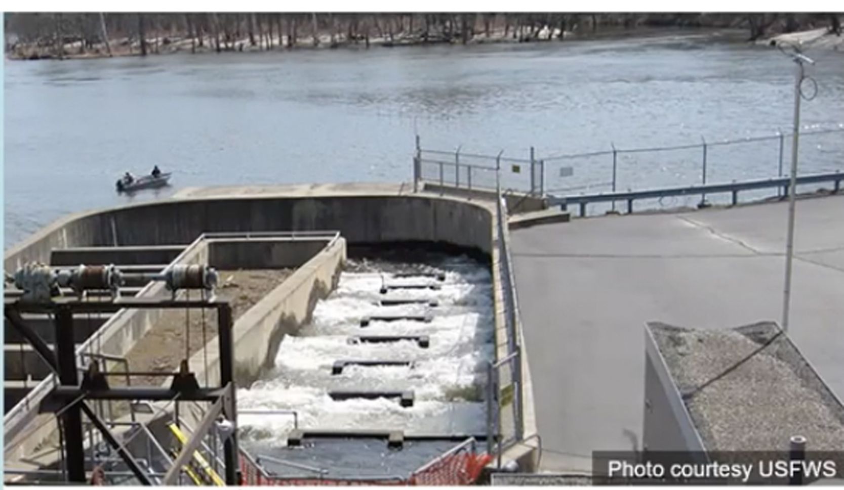
Connecticut River Steward Cathy Urffer told VT Digger in March that “for decades, hundreds of thousands of shad have been successfully lifted via a fish elevator over the Holyoke dam (first dam on the river, in MA), only to be stymied by the next obstacle upstream — the Turners Falls dam in MA. On average, only 5 percent of those migratory shad are able to pass the fish ladder at the Turners Falls dam and move up the river to Vernon. A 5% passage rate is unacceptable. At the Vernon dam fish ladder, about 43% pass in any given year, but that is too low, and the shad are exhausted. On average they spawn only once or twice when they should be able to spawn for three years in a row.”
Eels are one species that moves down river. They mature in rivers and return to the Sargasso sea in the Atlantic Ocean to breed. One study found that 60% of seaward-migrating eels were killed by hydroelectric turbines and many of the surviving fish were injured. Due to declining numbers the eel has been considered for listing as an Endangered Species.
That's not to say that the river is devoid of fish by any means. We have lost fish that thrive in cool, fast-running waters, but they have been replaced by warmwater species like walleye, perch and bass. Vermont introduced walleyes by the million between 1912 and 1932. The Connecticut is still a fishing destinaton.
In 2021 the relicensing process is finally nearing its end stages. The new license proposes that continuous water flow will be allowed and the turbines will run all the time. Changes in water level will be kept within a one to one-and-a-half foot band. To allow Great River Hydro to take advantage of periods of higher electricity prices there is an agreed-upon flexibility in water release so the levels can fluctuate outside of this band. Thus, in the months of December through March 65 hours of flexible releases will be allowed. In April through June, when sensitive species are spawning, flexible releases will be limited to 10 hours, but they will increase to 20 hours in July through October and to 42 hours in November. When the water flow is increased there will be a more gradual up-ramping so it takes one hour to go from 800 cubic feet per second to 8,000 cubic feet per second. The down-ramping will be even more gradual over several hours.
These changes do not significantly impact Great River Hydro but the benefits to the river are enormous.
However, Great River Hydro made no significant improvements in their license application regarding fish passage, bank “erosion”, cultural resources or recreation. They propose to maintain three existing primitive camp sites and to operate existing fish ladders from April 1st through July 15th. Additional fish passage requirements will be discussed and they will work on developing a program for managing historic sites.
And what of bank collapse? It would certainly seem that keeping changes in water level within one and a half feet at the Wilder dam could reduce the problem.
Cathy Urffer, in a recent presentation to the Thetford Conservation Commission, cautioned that the Fifteen Mile Falls dams, upriver from the Upper Valley, were relicensed in 2001 and have permission to use hydropeaking for the next several decades. Two of these dams are massive compared to the Wilder dam. The closest, McIndoes, is comparable to Wilder at 25 ft high, however Comerford is 170 ft high and Moore is 178 feet high. Whether the surges of water from their hydropeaking will affect our region cannot be measured till hydropeaking stops at Wilder.
And relicensing is not over yet. There is still a Public Comment Period, perhaps opening as early as the end of May, or as late as July.
It is important for the public and towns to submit their comments so that local concerns and desires may be considered in the new license. The Federal Energy Regulatory Commission needs to hear from the public, not just Great River Hydro, in order to manage historic and cultural sites and balance ecology and access, for the benefit of the public and of the river.