
Watershed Action Plan; Halting Lake Fairlee pollution requires cooperation of many
Once projects are identified, conceptual designs will be made and a draft Lake Watershed Action Plan will be released.
On Wednesday, February 22, the findings of the Lake Fairlee Watershed Assessment were presented to the public by Mary Nealon of Bear Creek Environmental and Lisa Niccolai, LakeWise Coordinator, via a Zoom meeting.
The Watershed Assessment is a survey of the watershed around a lake that identifies the primary causes of water quality and habitat degradation that affect the lake. These include the health of the shoreland buffer and sources of phosphorus and sediment entering the lake.
The declining health of Lake Fairlee is of concern to many. It is evidenced by loss of water clarity caused by more and more algae which thrive on phosphorus and sediment. Measurement of Lake Fairlee’s water quality since 1979 by the VT Agency of Natural Resources shows “significant” to “highly significant” increases in phosphate levels and “significantly decreasing” water clarity. Overall, the lake gets a Trend Score of “poor” and a Water Quality Status score of “stressed.”
The most likely sources of phosphorus and sediment fall into three categories: road erosion, shoreline erosion, and stream erosion.
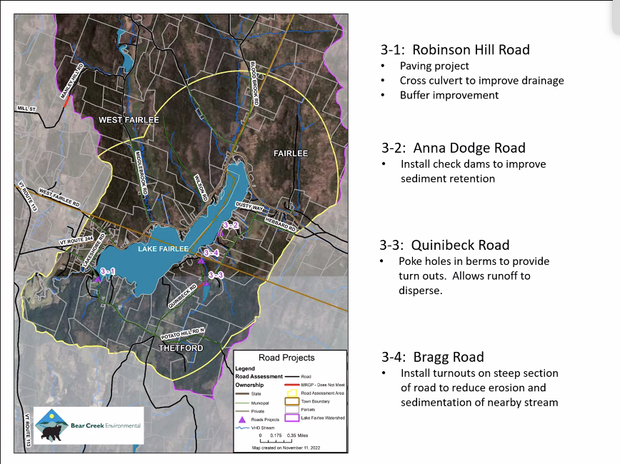
A survey of roads in a one-mile-wide zone around the lake did not identify any major problems. One section of Quinibeck Road did not meet the erosion criteria for municipal roads. An earthen berm was preventing dispersal of runoff and sediment. It appeared that the town was fixing this problem.
The unpaved section of Robinson Hill Road abutting the lake has been the subject of complaints, though it did meet the municipal road standards at the time of the study. However some bad spots have been reported by residents; a small gully that developed may have been corrected temporarily by the Town. The priorities for this road section are to install a culvert and to stop the town from mowing the vegetative buffer between the road and the lake. The springtime runoff of sediment would be further reduced by paving this road section.
Anna Dodge Road, a private road, and Bragg Road suffer from incorrectly channeled runoff that allows water to concentrate sediment and pick up phosphorus. Check dams to slow runoff velocity or turn-offs to dissipate runoff would correct these problems.
A 2016 survey of the lake shore buffer zone within 250 feet of the water’s edge showed that 70% of this area was covered by forest or trees of some sort. This is better than some other VT lakes. There are also areas of wetland protecting parts of the shore. In addition, LakeWise program coordinator Lisa Niccolai has met with fifteen private lakeshore property owners to discuss managing their properties in the buffer zone to better benefit the lake.
Eight shoreline projects to limit sediments and phosphate were identified. Two involve artificial beaches where runoff washes sand into the lake. One is at Thetford’s Treasure Island recreation area, and the other is at Ohana Camp. In both cases a french drain around the perimeter of the beach area would ameliorate the situation.
There are other runoff issues at Treasure Island, one coming from the access road and another from a picnic area that lacks a consistently wide vegetated buffer. At Horizons Day Camp, runoff from a roof is causing erosion near the lake. Both Horizons and one private landowner also have failing and eroding waterside retaining walls. A recommended solution would replace them with a bioengineered structure that rebuilds a natural, stable shore to protect water quality, add wildlife habitat, and dissipate wave energy.
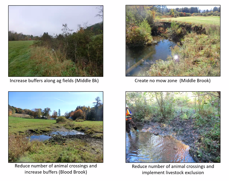
Lake Fairlee is fed by twelve inlet streams. Two major inlets, Middle Brook and Blood Brook, make up 70% of the total watershed contribution. Problematic situations on Middle Brook include a hayfield without an un-mown vegetative buffer along the brook. The brook is actively migrating and eroding its channel in places, releasing sediment and phosphate towards the lake. On Blood Brook there are stream bank erosion problems due to livestock. Again there are no buffers, and animals are allowed to cross anywhere, trampling, adding excrement, and reducing the banks to mud – i.e sediment. Unfortunately these landowners are resistant to making changes and say they cannot afford to reduce the area they are haying or grazing by establishing buffers or fencing their livestock.
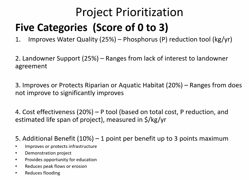
The next steps with the Watershed Action Plan are to decide which of the many projects are highest priority (see table).
Once projects are identified, conceptual designs will be made and a draft Lake Watershed Action Plan will be released. The prioritized list of projects can then be entered into the Department of Environmental Conservation Watershed Projects Database to be considered for funding under the Clean Water Initiative Program (CWIP) and other sources of financial support.
But at the heart of it, community members are the most essential component of any solution for a clean and healthy lake. The Town can address road issues, but the majority of the land around Lake Fairlee is privately owned, and few solutions will be realized without private landowner participation.