
The huge development that wasn’t
The land was purchased sometime in the late 1980s, and subdivision designs were crafted.
It would have been the biggest single housing development in Thetford. A 79-acre piece of land, much of it open fields, once occupied the area in Post Mills bounded by the Ompompanoosuc River, the West Fairlee Road, Cross Street, and Route 244. In the mid-to-late 1980s, two developers, Peter Bouchard and James MacDonald, began eyeing that land. There was regional pressure for housing, and a building boom was in full swing. The two conceived plans to create a subdivision of 56 lots, the scope and scale of which had never before been seen in Thetford.
The land was purchased sometime in the late 1980s, and subdivision designs were crafted. This did not go unnoticed by nearby landowners on Cross Street, who began to voice concerns that their shallow drinking water wells would be endangered by the proximity of so many septic systems. Another worry was how this many homes would coexist without friction with adjacent Crossroad Farm.
Perhaps in response to these voices, or for purely pragmatic reasons, the project was soon scaled back to 16 lots. Even so, there was no question that the size of this development placed it under environmental review by the District Environmental Commission (DEC) and Act 250. The 16 lots would accommodate single family homes and four duplexes, a total of twenty-three units. Two new roads were part of the plan, one – Pete’s Way (after Pete Bouchard) – coming off Rt 244 near the church, and the other – Mac’s Way (after James MacDonald) – coming off Cross Street. Mac’s Way would serve eight single family homes and four duplexes. The project was divided into three phases – first eight units, then another seven units, then the final eight. Two more buildings, one of them another duplex, could be allowed at a later date.
The subdivision was approved in March 1990, subject to various conditions. A fire pond “and associated hydrant shall be in place and certified satisfactory and operational before … issuance of a building permit for the fourth dwelling unit” to meet the fire safety standards required at the time.
The subdivision was centered around an 18-acre field that would be kept as open space and agricultural land. The community wastewater treatment system would conveniently be installed under this field, and there would be four pumping stations to move septage from all the houses to the system. Many lots would have easements for the sewage pipeline. Each home would have its own deep drilled well, presumably to reduce the likelihood that the development would compete for water with the shallow wells of the neighbors.
A homeowners’ association, the Ompompanoosuc River Properties Homeowners’ Association, was formed as one of the conditions of the Act 250 permit to take care of the communal septic system and the private roads. This was one of many covenants governing various aspects of the development. Others included unobstructed storm drainage, tidy trash, agricultural use, etc.
There would be a fifty-foot buffer to separate house sites from the boundary of the Taylor farm, and a 100 foot buffer between the lot designated for the four duplexes and the 18 acre agricultural lot.
Another sizable lot located by the Ompompanoosuc River was designated for open space and river access. It contains wetlands that the Agency of Natural Resources found to constitute “rare and irreplaceable natural areas.”
The DEC noted that the subdivision “meets the Town Plan’s recommendations for planned subdivisions incorporating reserved natural areas. However the Thetford Planning Commission indicated that the project did not conform to the Town Plan “because it creates lots that cannot support their own septic system and because a community septic system is proposed on primary agricultural land.”
Of particular note, the DEC considered the impact that a development of this size would have on Thetford Schools. During the 1980s, the development boom had resulted in schools being filled to capacity. Residents were not overly welcoming to the thought of more families bringing in children. The DEC predicted that “at full build-out the project will contribute 30 to 35 students. The Thetford Elementary School is at, or near, capacity. The applicant has agreed to build the project in three phases over three years. The applicant will also provide impact fees in accordance with the Town’s impact fee ordinance. These measures are appropriate to prevent an undue adverse impact under this criterion.” The developers were required to “provide appropriate impact fees to the Town” prior to the completion of any unit “addressed by the fee.” Even so, some residents believe that, had this project been fully built, Thetford would have been required to have a Middle School that today would be sitting empty.
The DEC also found that the proposed housing units “... do not constitute a commonly recognized definition of affordable housing” because the units would be priced at around $150,000. However, since the Town Plan only had the goal of providing a “range of affordable housing opportunities,” the project neither met nor violated the Town Plan. Overall the project was approved because it preserved the Ompompanoosuc River shore and agricultural land, built clustered housing, and avoided adverse effects on regional services and character.
That was in March of 1990. But in spite of their goal of completing eight units in the first year, seven in the second year, and the final eight in the third year, the developers built only one house. While the financial circumstances are not clear, it is possible that a hydrological mapping of the subdivision area, plus a recession around that time, depleted their resources. Their delinquent property taxes from 1993 amounted to about $6,630 “plus interest, penalty and costs.”
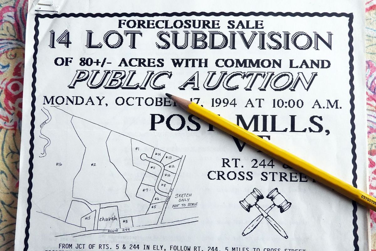
In 1994, on October 17th, the lots were auctioned off at a tax sale. The auction, held on a Monday morning after the end of foliage season, attracted surprisingly little attention. Only three qualified bidders showed up. At the end of the bidding process, Richard Balagur held the majority of the lots, Tim Gray had two, and Tim and Janet Taylor of Crossroad Farm came away with the 18-acre field, a couple of house lots, and the acreage along the Ompompanoosuc that was mostly wetlands.
After that, development happened slowly as lots were sold to homebuilders in a piecemeal fashion. About nine or so of the homes have been built, and none of the duplexes. At least one lot on Mac’s Way remains open. The fire pond was scaled back, as the Fire Department changed the way it dealt with fires. The community septic system was also reduced in size and complexity, serving only part of Mac’s Way.
What did happen was a huge expansion of Crossroad Farm that now encompasses the 18- acre central parcel in addition to 20 acres acquired in 1982 after another subdivision proposal with access to the West Fairlee Road was denied under Act 250. When the Taylors started farming, they had 15 acres, and with all the hard work in the world they could never have built the thriving agricultural enterprise that stands today. Inadvertently, perhaps, Act 250 enabled their farm to grow to a sustainable size without spilling beyond this area of prime agricultural soil. Today the land is being put to its best use – growing crops for the benefit of the greater community.