
Treasure Island; Shoreland Protection Analyst issues memorandum
It remains to be seen how the Town will proceed from here.
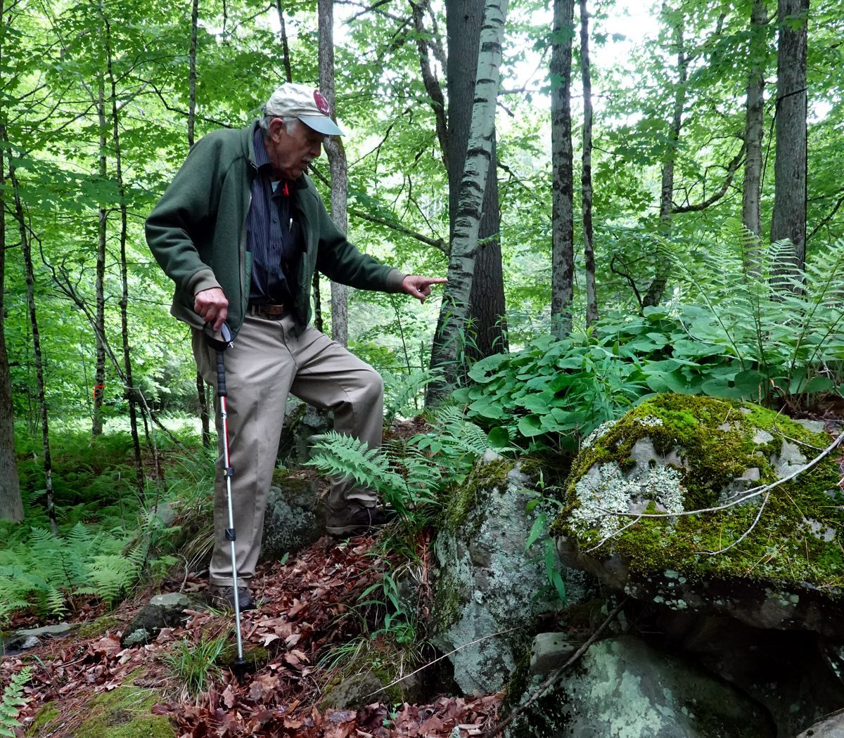
Earlier in the month, Misha Cetner, the Lakes and Shoreland Permit Analyst from the VT Department of Environmental Conservation (DEC), and Alison Marchione, the DEC Lakeshore Manager who heads the Lake Wise program, paid a site visit to Treasure Island. They walked the routes of the trails proposed by the Treasure Island Exploratory Committee (TIEC) accompanied by TIEC Chair David Roth, Selectboard Chair Sharon Harkay, Town Manager Bryan Gazda, and Li Shen. They also looked at what is left of old trails that hug part of the north shoreline.
The examination of trail routes was not focused on wildlife. In fact wildlife were not mentioned during the visit. It is the intent of the Lakes and Shoreland Act, adopted in 2014, to “regulate activities within 250 feet of the mean water level of lakes greater than 10 acres in size, to allow reasonable development along the shorelands of lakes and ponds while protecting aquatic habitat, water quality, and maintaining the natural stability of shorelines. “ It applies to “creation of cleared area or impervious surface within 250 feet of the mean water level…….where vegetative cover has been permanently removed or altered. Vegetative cover includes tree canopy, understory, groundcover and the duff layer.”
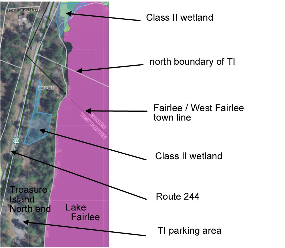
Misha carefully weighed the pros and cons of the north shore proposed trail and the remnant of the old trail. In both cases, opening these trails would require disturbance within the 250-ft regulatory zone. Both Misha and Alison noted that the proposed trail would also pass through Class II protected wetlands as it looped back to the parking area near the beach.
Regarding this area, Julie Follensbee, the VT State District Wetland Coordinator, wrote, “There are confirmed Class II wetlands on the north portion of property. I’ve sketched in blue approximately where I observed wetlands during a 2020 site visit to the property to review a different proposal. This is not an accurate boundary, nor does it show the regulated 50-foot buffer zone. At that time, we suggested that a wetland delineation would be a good next step to determine the actual wetland boundaries for planning purposes. I still recommend that. Here is a list of consultants that do that work.” An approved contractor could cost the town up to $3,000.
If educating children about nature was a goal, Misha and Alison noted that children learn better when they are taken on a supervised, guided tour. They learn little, if anything, when walking around untutored.
Sharon Harkay suggested that a winter snowshoe walk on the north shoreland would not impact the protection zone as the ground would be frozen. Trees would be leafless, leaving the view of the lake more open.
The group also examined the area south of the beach that encompasses the “island” linked to the rest of the property by a short causeway, plus the adjacent shoreland that is wooded and bounded on one side by the septic system. TIEC also proposes a nature trail in this wooded area that borders on David Roth’s land. Earlier in the year, a group including TIEC members and Lisa Niccolai, a forester who is trained to administer the Lake Wise program, had walked this loop as well. TIEC member and naturalist Dale Gephart had pointed out native wildflowers, such as wild ginger, along this route. This is one of the very few occurrences of wild ginger at Treasure Island. There is also a scenic rock outcrop on the proposed route, and there are no wetlands.
Following this site visit, Misha sent the following memorandum to the Town Manager:
“Based on our discussion, it appeared that there were some less intrusive feasible alternatives to the proposed trails along the northeastern shoreline. While there is an old trail along this section of shoreline, it’s poorly defined the further out you go (which would require clearing new areas to build an expanded/rerouted trail), the existing trail and potential new trail is still fairly close to the water, and it appeared that a sizeable portion of new trail would be routed through protected class II wetlands. Some of the less intrusive alternatives we discussed were to have the current trail be used for winter snowshoe events (no creation of new/expanded trails needed) or the current trail could be used to have a guided walk through the area (not requiring new/expanded trails either and folks just walk through the woods). So the area could still be utilized for educational opportunities, but done so in a way that wouldn’t potentially impact the other goal of shoreline/wetland protection.
“The other part of the discussion was focused on the peninsula and land immediately behind it. This area is already fairly developed along with having a mostly forested shoreline. It appeared that this area could be utilized to achieve the same/similar goals that were envisioned for the northeastern shoreline. Additionally, it was discussed how, if revitalizing use of the peninsula and land behind it was not enough for achieving the goals of the project after some time had passed, then that would be a way to demonstrate more of a need to expand trails into the northeastern section of shoreline.”
It remains to be seen how the TIEC will proceed from here. However, it should be noted that town committees are under the Selectboard, while the Town Manager, by statute, is responsible for “the maintenance of parks and playgrounds.” (Vermont Statutes; Title 24, Chapter 37.)
Wetland diagram courtesy of Julie Follensbee, District Wetland Coordinator, VT DEC. Photo credit: Li Shen.