
Trails and natural resources, what’s next?
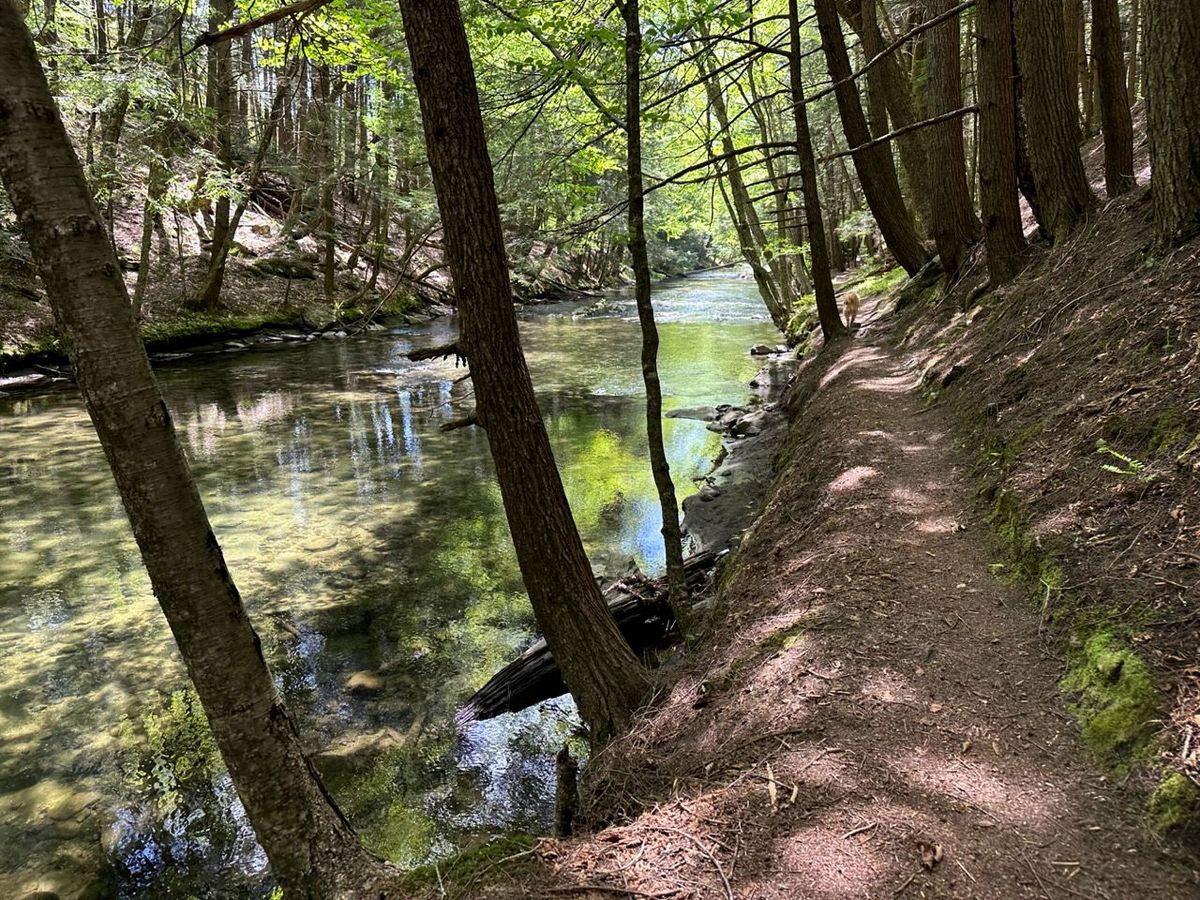
The trails in the Army Corps of Engineers flood control area have been open to the public for decades. Unfortunately, unauthorized trail building became a problem.
On Wednesday May 24th after careful public outreach, Thetford Academy hosted a presentation on the Thetford Hill/Union Village trails network. The Outdoor Programs Coordinator from Thetford Academy, Scott Ellis, enthusiastically opened the meeting. Next came Conrad Reining, the unofficial “leader” of a group known as the Thetford Trails Team (TTT). He gave a preamble about the necessity for, and funding of, the evening’s highlight, a summary of the Natural Resources Inventory of the area conducted and presented by biologist Jesse Mohr of Native Geographic. This study was commissioned by the TTT using private funding administered through the Town.
The area in question is home to a premium natural feature, the east and west branches of the Ompompanoosuc River flowing to their confluence to create the Ompompanoosuc Main Stem. Associated with this river feature are undeveloped floodplains — a rarity in Vermont — and long stretches of wild riverbank, or riparian area — a limited commodity on lower river reaches throughout the state. Beavers make their home here, and otters have been sighted as well. There are also rocky crags used by bobcats, outcroppings and talus slopes for porcupines and fishers, and many wetlands and vernal pools that are hotspots of biodiversity and breeding grounds for salamanders, frogs, and dragonflies.
Repeated flooding near the Union Village Dam has created a complex of shrubby areas and open herbaceous zones that shelter diverse scrubland and grassland-nesting songbirds. These areas are in contrast to many different types of forest coexisting on the uplands. Here, interior forest birds like scarlet tanagers, wood thrushes, hermit thrushes, blue-headed vireos, etc. find shelter and breeding habitat. Many of these trees produce nuts (oak, beech, and hickory) or soft fruits (black cherry, juneberry, apple) that are essential foods to many wildlife species including migrating birds, deer, turkey, grouse, fisher, squirrels and other rodents, and, potentially, bears. This remarkably rich terrain hosts several rare or endangered species such as the northern long-eared bat that is endangered both state-wide and federally.
Jesse managed to summarize the impressively comprehensive, 72-page report in about 30 minutes with a focus on whether and how these natural resources are impacted by the current system of trails.
The trails in the Army Corps of Engineers (ACE) flood control area have been open to the public for decades. Unfortunately, unauthorized trail building became a problem, perhaps spearheaded by a very few people in the early 2000s and much to the frustration of former ACE Natural Resources Manager Gary Pelton, who understood both the uniqueness of this area and its fragility. There are also trails in the nearby areas of forest dotted with wetlands owned by the Academy and the State Park. These have expanded, and connections now cross private lands, with owner permission.
Trail use has steadily increased over the last decade, accelerated by the pandemic. Furthermore, intense rainstorms are more frequent, which, coupled with wear and tear and decreased vegetative cover in vicinity of trails, is a recipe for slope erosion and river bank collapse.The Academy, the Town Conservation Commission and the TTT that represents mountain biking, hiking,and cross country skiing interests as well as private landowners, realize that some form of stewardship of this system is necessary. In fact the ACE has already entered into a trails management agreement with the Upper Valley Mountain Bike Association that has trail stewardship experience, with the TTT serving as the local liaison. This agreement does not apply to trails on non-ACE lands .
As Jesse summarized, at present the trails do not impose a major environmental impact. However, in many areas they are starting to threaten valuable natural resources. The mere presence of a trail can deter wildlife from using an area, as detailed in a publication by the NH Department of Fish and Game, and unleashed dogs magnify this effect. For this reason trails should not hug the shore of a valuable water resource like a pool, river, or wetland or the bases of ledges and cliffs that are bobcat refuges. It is also important to keep trails to the edges of forest blocks, shrub zones, and other sensitive habitat. Cutting through the middle creates a zone of disturbance as wide as 800 ft for mammals and 600 ft wide for birds. The report recommends: “Decommission primitive/light use trails to protect remaining interior forest.”
High on the eight-page list of recommendations is modifying or replacing some of the structures that allow trails to cross water — stream or wetland — but are causing an impact, and to fix trails that are degrading due to poor design, often on slopes. Jesse’s work includes a table of 29 stream or wetland crossings that need anything from “High Priority work” to “Routine maintenance” and pinpoints 64 or so specific sites on trails that suffer from “Excessive grade” or “No erosion control.”
The report also lays out an overall strategy for managing the trails and resources. For a start, “Create or identify an organizational entity to oversee the trail system.”
“Stop construction of all new trails till improvement and maintenance planning is complete.”
“Relocate, decommission and prevent trail construction near sensitive and important natural resources.”
“Evaluate resources and capacity for long-term trails maintenance.”
“Finalize the design of the trail system” since the system never had an overall design and “there are more trails than are needed or can be maintained.”
“Develop and install a trail signage system.”
“Create a suite of trail improvement and trail decommissioning projects.”
“Develop a trail maintenance plan and log.”
And so on.
The last part of the meeting was devoted to informal discussion and sharing ideas about how to execute this strategy. It’s a tall order for the TTT, which started as an informal group of residents who love mountain biking. Perhaps looking to other towns would be helpful. Some towns have trail committees that work under the supervision of the town Conservation Commission. Stand-alone town committees also exist. Others, like Fairlee, have established a private non-profit. It seems essential that whatever the structure, it should be eligible to apply for grants. While volunteers can achieve a lot given suitable training, the report gives two-year or five-year timelines for many of its recommendations. Unless the ranks of volunteers swell to an army, they will need hired help to make significant progress.
Photo credit: Nick Clark