
The geological story of Thetford, Vermont
Most of Thetford's villages were recently under water.
Part I. Volcanic Arc
Imagine an arc-shaped line of volcanoes like the Aleutian Islands, lying off the eastern coast of New England from 470 to 445 million years ago, in the Ordovician Period of the Paleozoic Era. Except that at the time, the shoreline was over in Vermont, and the island arc was along the western border of New Hampshire. The continent west of Vermont is referred to by geologists as “Laurentia.”
Such island arcs form above subduction zones, where oceanic crust is drawn down into the mantle. Water released from the down-going slab changes the melting temperature of the overlying mantle rocks, producing plumes of magma that erupt at the surface to form volcanoes.
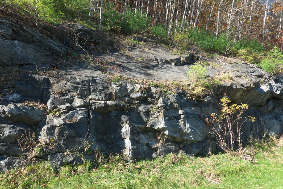
Black basalt and light gray, more silica-rich volcanic rocks such as rhyolite erupted around 445 million years ago in what is now the eastern part of Thetford, as part of this volcanic arc, which extended from Newfoundland to Connecticut. Much later, during the Acadian Orogeny (see below), high temperature and pressure changed the basalt to chlorite schist and amphibolite. The resulting metamorphic rocks can be observed along Clay Hill in North Thetford and in the I-91 road cuts south of John Quail Road.
Part II. Taconian Orogeny (mountain-building episode) and aftermath
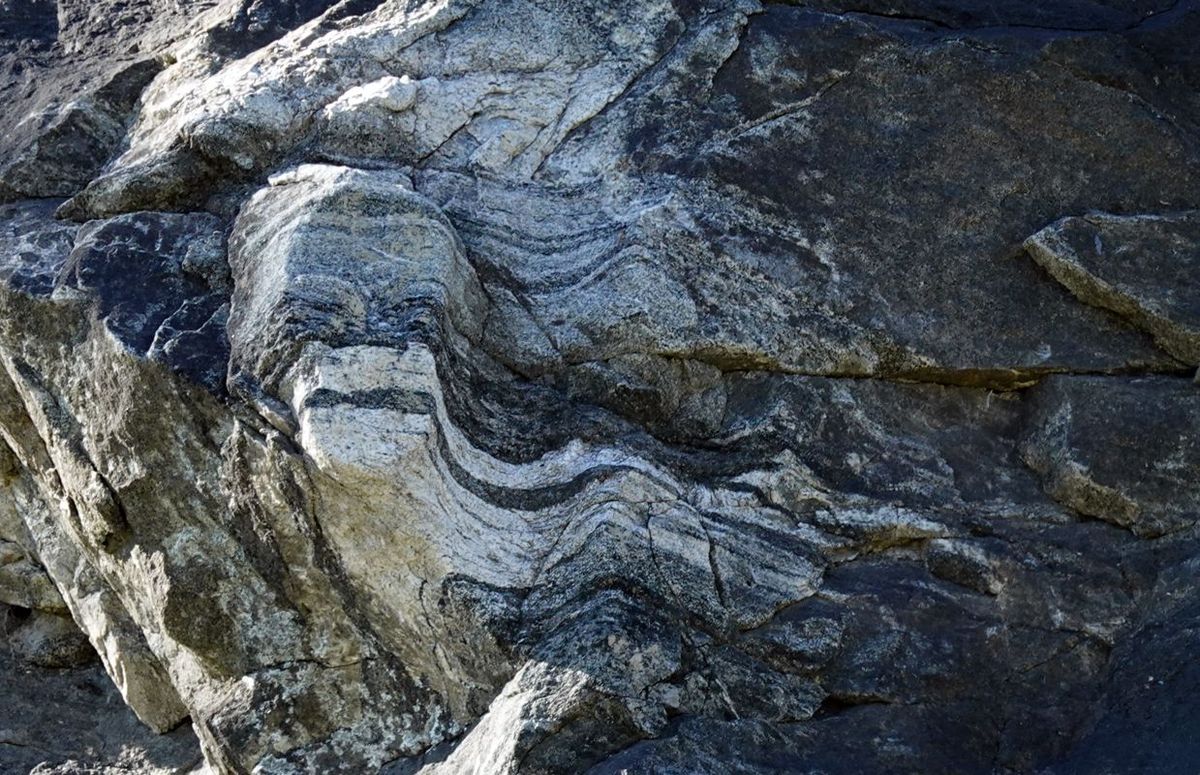
As the oceanic crust was subducted (drawn down) beneath the volcanic arc, the eastern margin of the continent trailed along behind, and eventually collided with the arc as the seaway between them closed. This collision produced the Green Mountains and the Taconic Mountains, adding material to the margin of Laurentia, so that after that, the shoreline shifted to somewhere in New Hampshire. The force of the collision folded and faulted the rocks, and the thickening of the crust raised the temperature and pressure to the point where, without melting, the rocks were metamorphosed into rocks containing new assemblages of minerals.
Over the next five million years, the remnants of the volcanic arc were eroded down to sea level and a clean quartz beach sand was deposited over them during the Silurian Period. The sand was compressed and cemented to form sandstone, which was metamorphosed during the Acadian to a very hard, resistant rock called quartzite. Outcrops of the quartzite can be seen as linear ledges on Cobble Hill and Wilmot Mountain. Much thicker deposits of the same rock unit (Clough Quartzite) hold up Lambert Ridge on Smarts Mountain, Mt. Cube and Black Mountain in New Hampshire.
Part III. Acadian Orogeny
Meanwhile, another volcanic arc had developed along the Maine coast as oceanic crust was subducted westward, bringing a land mass referred to as Acadia along behind it. The resulting collision produced huge mountains, and sediments from the erosion of the mountains were shed westward all across what is now New Hampshire and eastern Vermont. These sediments compacted over time to produce shale and muddy sandstone. Layers of rhyolite were also deposited, likely from ash fall events from distant volcanoes. One of these layers on I-91 east of Lake Morey has been dated at about 407 million years, which puts it in the Devonian Period.
Keep in mind that tectonic processes take place at agonizingly slow rates, on the order of 20 millimeters per year or less. Consider the present-day collision of India and Asia, which began about 40 million years ago.
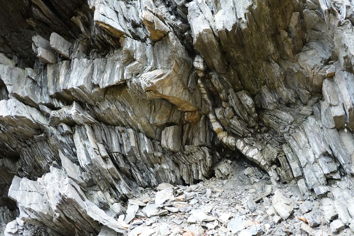
As the Acadian collision advanced westward over the next 20 million years, masses of hot rock were thrust westward, eventually involving the “recently” formed sedimentary and volcanic rocks. It was during this orogenic cycle that metamorphism reached maximum pressures and temperatures, transforming basalt into amphibolite, sandstone into quartzite and shale into slate and schist. Interlayered schist and quartzite are the dominant rocks in much of Thetford, all Devonian in age, and collectively referred to as the Gile Mountain Formation. They are well exposed in the river at Rices Mills, all along the east branch of the Ompomponoosuc, such as below the Sayre Covered Bridge in Thetford Center, and in a road cut along Rt. 244 on the west side of Lake Fairlee.
Part IV. Mesozoic Faults
A quiet time millions of years long followed, for which we have no geologic record in Thetford, except for evidence of some jostling as more land masses collided from the east to form the megacontinent called Pangea, which included all of the modern continents. At the end of the Triassic Period of the Mesozoic Era (about 225 million years ago), Pangea began to rift apart along several roughly parallel lines. Eventually one of these rifts kept opening to form the modern Atlantic Ocean. Others, like along the Connecticut River valley, stopped widening, but faults, thick quartz veins, basalt dikes and intrusions like Mt. Ascutney bear testament to this episode. In Massachusetts and Connecticut Mesozoic sandstones and shales still remain, locally with dinosaur footprints and plant fossils, but such rocks have long since eroded away in our part of New England. (You can see road cuts of reddish Mesozoic sandstone along I-91 near Greenfield, MA.)
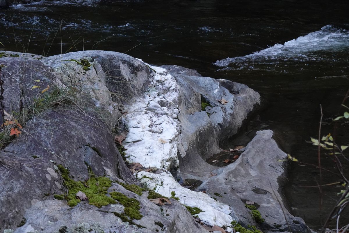
One of the Mesozoic faults trends southwest from Lake Morey through Thetford parallel to I-91 and then just east of Academy Road to Union Village. The Thetford Hill lead deposit, which consists of tiny amounts of galena (lead sulfide) in a thick quartz vein, is related to the Lake Morey fault. The ore formed as silica-rich water moved up along fractures in the Devonian rocks. The Gile Mountain Formation and so-called Meetinghouse Slate lie entirely west of this fault, whereas Littleton Formation, Clough Quartzite and Ammonoosuc Volcanics lie to the east. The latter rock units are all widespread in western New Hampshire, but only appear in easternmost Vermont.
A second big fault, the Ammonoosuc fault, extends the length of New Hampshire and beyond. In Thetford, it runs east of and parallel to the Lake Morey fault from about North Thetford southwest under Conant Swamp to roughly follow Godfrey Road. Rocks east of this fault also belong to the New Hampshire sequence, but they are at higher metamorphic grade, meaning they attained higher temperatures than the same rock units between the faults. For example, the metamorphosed basalts are low-grade chlorite schist at Clay Hill, but higher-grade amphibolite in the southeast part of town. We think that the block between the two big faults moved relatively downward (called a “graben” by geologists) but we don’t know for sure.
Part V. Glaciers
The last materials to cover the landscape were deposited by continental ice sheets advancing from the north during the Pleistocene Epoch, starting around two million years ago (just yesterday!). In fact, the last ice wasted away (“retreated”) only about 12,000 years ago, leaving behind a layer of glacial till, a mixture of clay, silt, sand, cobbles and boulders. A moraine (ridge) of till in Connecticut blocked the river for a time, and a huge lake, dubbed Lake Hitchcock, backed up behind the glacial dam, reaching all the way to Burke, Vermont. All the village centers except Thetford Hill were submerged under Lake Hitchcock at that time. Places like Bill Hill, Cobble Hill and Wilmot Mountain would have been islands in the lake. Streams flowing into the lake built up deltas of sand all along the shore, for example along Rt. 113 between Post Mills and Thetford Center where the sand persists to this day. Lake Hitchcock lasted for about 2,000-3,000 years until the moraine was breached, the lake drained, and the modern system of rivers and brooks began to develop. In our area the original Lake Hitchcock shoreline now stands at about 710 feet above sea level. It gained elevation because the land rebounded after the massive weight of the ice was gone. This rebound was more pronounced in the north where the ice had been thicker, than in the south.
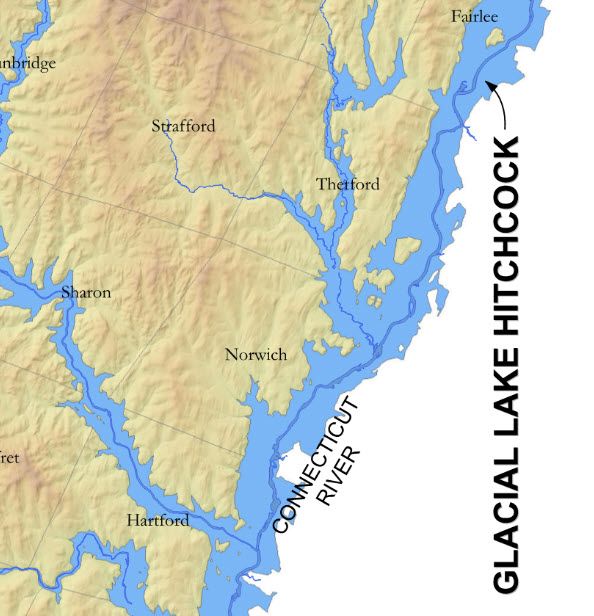
Photo credit: Li Shen