
Flood regulations; why and wherefore
The Selectboard will hold a hearing on August 23rd to consider updated flood regulations.
The Selectboard will hold a hearing on August 23rd as the near-final step toward approving Thetford’s proposed updated Flood Hazard Area Zoning Regulations (aka Flood Regulations).
The State of Vermont gives towns the authority to adopt such regulations in order to limit development in flood hazard areas. To some that might seem unfair; after all, settlements historically were established near rivers, within the best arable land and where they could harness the water power of rivers to run mills. However, we’ve come quite a way since then. While it may be convenient and certainly lovely to dwell by a river, history has revealed some serious downsides.
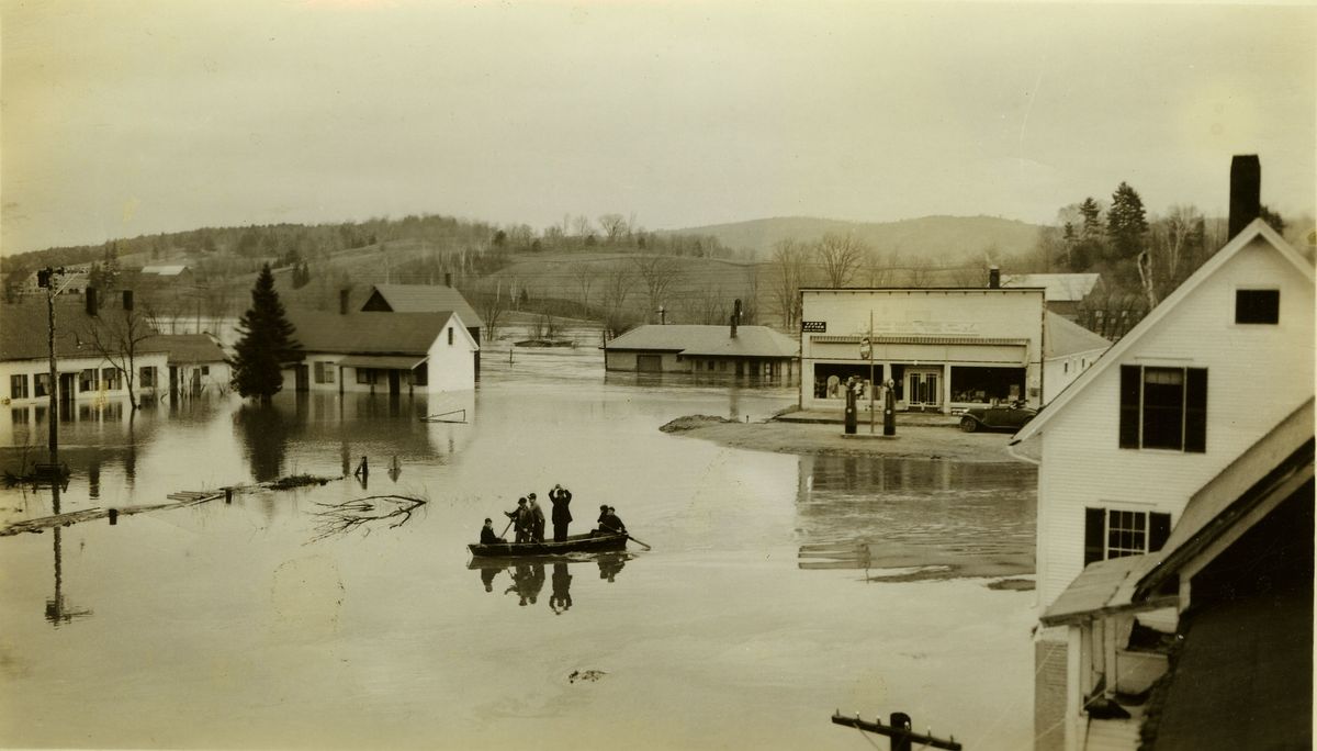
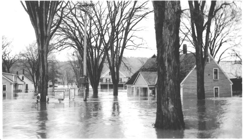
The flood of November 1927 is legendary. The State of Vermont received 10 inches of rain that fell on frozen ground. One thousand, two hundred and eighty-five bridges, and many miles of roads and railways were destroyed, as were “countless” homes. The flooding killed 84 people, including Vermont’s Lieutenant Governor S. Hollister Jackson. Locally, on the Connecticut River, East Thetford in particular was memorably inundated.
Another Connecticut River flood in March 1936 destroyed the iron bridge between Thetford and Lyme.
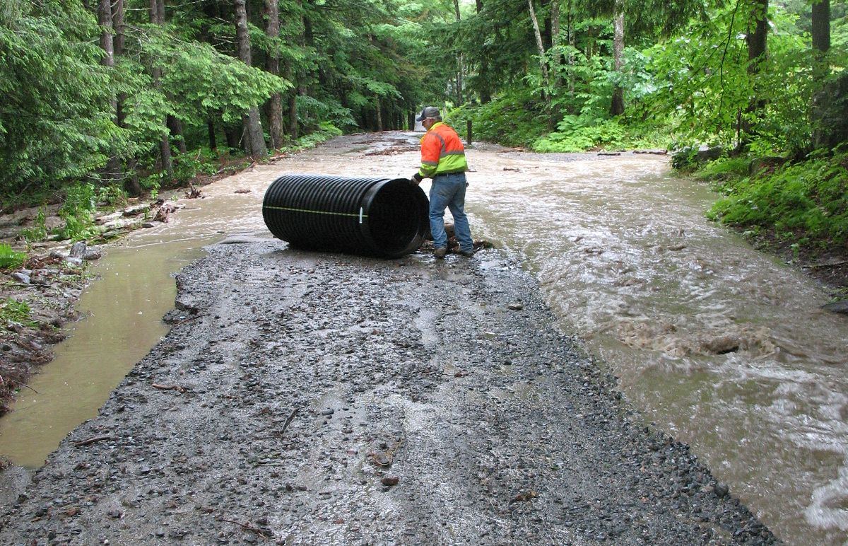
More recently in 2003, a torrential storm dumped 4 inches of rain in a single hour in one location in town. Tucker Hill Road, an important connector across the Ompompanoosuc, was washed out by a stream that overwhelmed its culvert. Poor Farm and Whippoorwill Roads were severely eroded. Repairing the aftermath cost Thetford $45,954.93. Severe rainstorms in 2008, 2009, 2011 (twice), and 2014 were accompanied by local flooding, as noted in the Town’s Hazard Mitigation Plan. Tropical Storm Irene in August 2011 dropped 4-5 inches of rain here in less than two days. Thetford got off lightly with only $22,800 worth of damage to Rt 132 and other roads and culverts. Our 2017 Hazard Mitigation Plan comments that statewide “the flooding that occurred as a result of Tropical Storm Irene is considered to be greater than a 100-year flood event, and likely closer to a 500-year flood… (it) is considered to be the second greatest natural disaster in 20th and 21st century Vermont; second only to the Flood of 1927.”
The storm and floods in Thetford on July 1, 2017, are still fresh in our memory. Many residents were cut off completely, there were long power outages, and Thetford’s roads sustained a devastating amount of damage totaling more than 4 million dollars.
The accelerating pace of climate change means that familiar weather patterns may disintegrate. In particular, recent years have seen an increase in the number and severity of storms and torrential downpours in Vermont.
Flood hazards may be divided into two categories, inundation (submersion in water) and fluvial erosion, when rapidly moving floodwaters carve away the surrounding land. In most heavy rainstorms both occur.
A floodplain is a generally flat area next to a river that stretches from the banks of the river to the outer edges of the valley. The 100 year floodplain, or Base Floodplain, is the area that has a one-in-one-hundred chance of being inundated in any given year. This is also known as the Special Flood Hazard Area. Within the 100-year floodplain, the Federal Government defines the “floodway” as the river and the area beyond the river banks that is essential to the effective conveyance of floodwaters. Beyond that is the flood fringe that does not effectively convey floodwater but is important for floodwater storage. Placing buildings in the Flood Hazard Area is akin to placing bricks in a bathtub of water. It raises the flood level and reduces the volume of floodwater that can be stored. Flood damage creeps higher up the sides of the valley, while less flood storage means that more floodwater gets sent to everyone downstream.
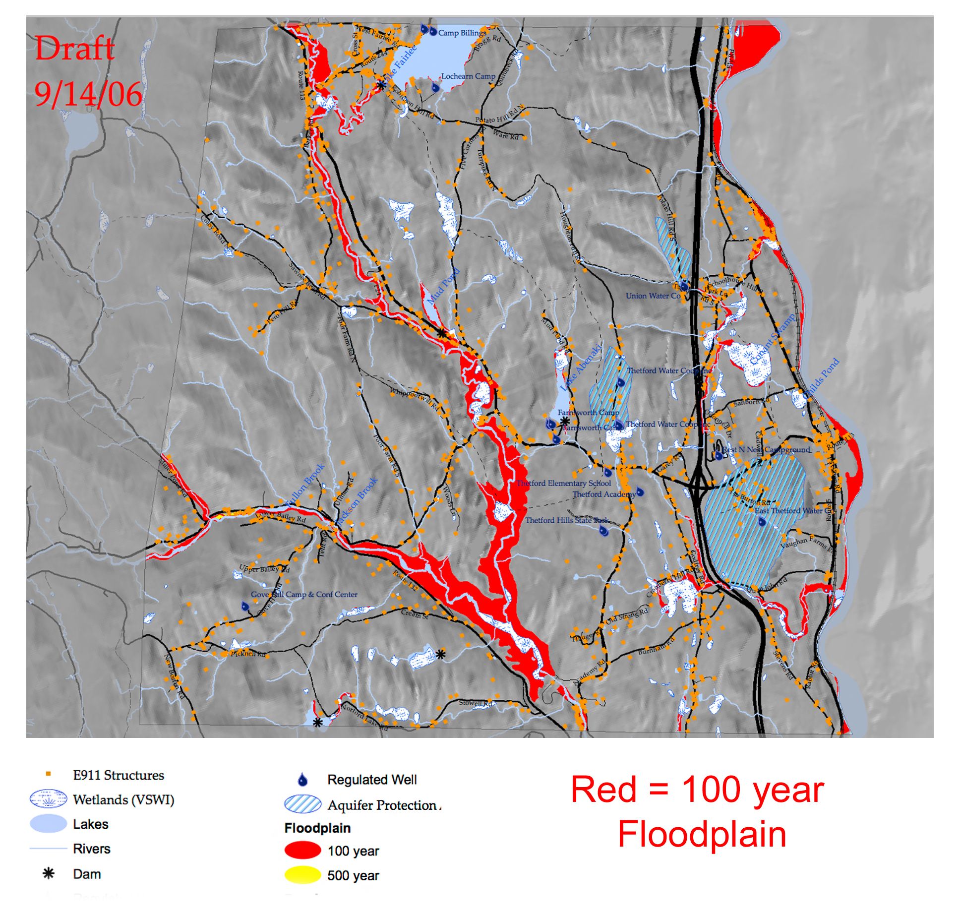
In Thetford, there are 1,666 acres of mapped floodplain accounting for 6% of the Town’s land area. Within those floodplains there are 58 acres of mapped floodway.
Thetford's Hazard Mitigation Plan states “Rivers, brooks, and streams in Thetford that have mapped Special Flood Hazard Areas include the Ompompanoosuc River, the West Branch of the Ompompanoosuc River, the Connecticut River, Abbot Brook, Lake Fairlee, Lake Abenaki, Mud Pond, Zebedee Brook, and Gunn Brook. Other significant streams that flood frequently include Blood Brook, Jackson Brook, and Fulton Brook. In Thetford there are 80 structures at risk of inundation in the Special Flood Hazard Area. These structures consist of 65 residential buildings (48 single family homes, 11 camps, 2 mobile homes, 1 other building, and 3 accessory units), 10 commercial/industrial/government structures, and 5 properties classified as ‘other.’ If all of these properties were destroyed in a flood, the resulting damage would be approximately $21,765,260.”
Approximately half of the residential structures at risk are in North Thetford Village.
The State of Vermont has also conducted mapping to identify areas along rivers, streams, and brooks that are vulnerable to fluvial erosion. These are identified as River Corridor Areas. In Thetford the mapped River Corridor Areas include the Ompompanoosuc River, The West Branch of the Ompompanoosuc, Zebedee Brook, Avery Brook, Lord Brook, Jackson Brook, and Barker Brook. The Hazard Mitigation Plan states: “In Thetford, there are 51 structures in the mapped River Corridor Areas. These structures are at risk to fluvial erosion. These consist of 47 residential properties and 4 structures classified as ‘other.’ If all of these structures were destroyed in a flood, the resulting damage would be $11,221,632.”
The State encourages municipalities to adopt Flood Regulations to “minimize and prevent the loss of life and property, the disruption of commerce, the impairment of the tax base, and the extraordinary public expenditures and demands on public services that result from flooding and other flood related hazards.” Thus, the Flood Regulations deter most types of new construction in Flood Hazard Areas.
Thetford’s Flood Hazard Area Bylaw was last updated on 07/14/2008. There are three changes to the Bylaw in the draft that will come before the Selectboard on August 23rd. These were made to bring our Bylaw in line with the 2018 model language by the State of Vermont that meets National Flood Insurance Program standards. (1) In Flood Hazard Areas where the regulatory floodway has not been designated, development would not be permitted that would raise the water elevation of the base flood, as certified by a licensed professional engineer. (2) In the floodway fringe, any substantial improvements to residential buildings including mobile homes shall have the lowest floor elevated to a minimum of two feet above the base flood level. (3) In the floodway fringe, improvements to existing non-residential buildings shall have the lowest floor elevated to a minimum of two feet above the base flood level.
In big disasters, such as the 2017 storm, the Town becomes eligible to apply for financial aid to repair public infrastructure through FEMA (Federal Emergency Management Agency) and the Federal Highway Administration. Private homeowners who live in flood-prone areas are obliged to obtain flood insurance through NFIP. And here’s another reason to adopt Flood Regulations: FEMA states that “The NFIP works with communities required to adopt and enforce floodplain management regulations that help mitigate flooding effects.” In other words, no Flood Regulations, no federal flood insurance. The Town of Thetford first enrolled in NFIP on 6/3/1991.