
A Stewardship Plan for Treasure Island
By identifying Management Units that have different focus areas we can begin to balance competing uses for the property.
The Treasure Island Stewardship Plan was commissioned by the Town of Thetford as part of ongoing discussions about the recreational uses and ecology of this important lakeside asset. The town hired Lisa Niccolai, Conservation Specialist with the White River Natural Resources Conservation District, to prepare the plan. Lisa was already very familiar with the property through her Lakewise evaluation of Treasure Island.
Treasure Island comprises 11.48 acres along the northwestern shore of Lake Fairlee. It is bounded on the west by Rt. 244 and on the east by the lake. Private land abuts it at north and south ends. After years of varied land use and some disrepair, Treasure Island is in need of a vision that enhances the ecological benefits of the property while enhancing community recreation.
All of Treasure Island is a shoreline forested riparian buffer with an important role in protecting the health of the lake. Riparian forests support many different functions: trapping sediment, storing phosphorus and nitrogen, stabilizing shorelines, reducing flood waters, moderating water temperatures, providing wildlife travel corridors, and supporting in-stream and terrestrial habitat while providing recreational opportunities. The unique opportunity on this property is to provide features in the riparian forest that may be missing in other areas of the lake.
The New Hampshire Habitat Action Plan states that the quality of shoreline habitat may be the single biggest influence on the abundance and variety of wildlife that live near a waterbody. In Vermont about 45% of lakeshores have been cleared of native vegetation. Yet a whopping 60% of protein for freshwater fish comes from insects that fall from shoreline trees and plants.
Riparian forest areas attract a wide spectrum of wildlife. The lake is a natural opening in the forest, allowing sunlight to reach the forest floor. The warmth and light promote multiple layers of shoreline vegetation. Mosses, lichens, ferns, and flowers thrive in the sunny, moist conditions while diverse shrubs and trees create layers of vegetation up to the forest canopy. The sheer variety of plants supports myriad species from salamanders, beetles, and small mammals on the forest floor to songbirds, bats, and raptors in the overstory.
Riparian areas also offer an abundance of cavity trees and dead, dying, and downed woody material. This is important, but increasingly rare as shorelines become developed. Bats roost under the loose bark of dying trees, while flycatchers, kingfishers, bald eagles, and other birds use snags along the water for perching and feeding. Cavity trees provide nests for numerous species including barred owls, woodpeckers, and chickadees.
Dead trees that fall into the lake provide critical habitat features that other shoreland properties may not offer. Submerged trees provide shelter and breeding habitat for fish and aquatic organisms, while turtles sun themselves on boughs above water.
An important component of the riparian forest is the littoral zone - the nearshore zone where water and land intersect. Healthy shoreline has large areas of diverse underwater vegetation such as coontail and bladderwort mixed with pickerelweed and yellow pond lilies. Where these shallows abut deep water, wetlands, or forest, there are productive hunting grounds for great blue and green heron, otter, mink, and larger fish such as eastern chain pickerel and yellow perch.
The Shoreland Protection Act (SPA) regulates shoreland development within 250 feet of a lake’s mean water level for all lakes greater than ten acres in size. The intent of the Act is to prevent degradation of water quality in lakes, preserve habitat and natural stability of shorelines, and maintain the economic benefits of lakes and their shorelands. Any planned activities at Treasure Island should be reviewed to ensure compliance with the SPA.
Plan Purpose
The purpose of this stewardship plan is to help the Town of Thetford and its volunteers with the ongoing restoration of the natural areas at Treasure Island by identifying and prioritizing management activities. The goal is to cultivate a resilient forest that provides diverse wildlife habitat while providing ecosystem services to humans, such as stormwater retention, reduced flooding, carbon sequestration, and clean air. The plan also strives to balance the recreational uses on the property with the natural ecosystem to provide numerous and varied opportunities for visitors.
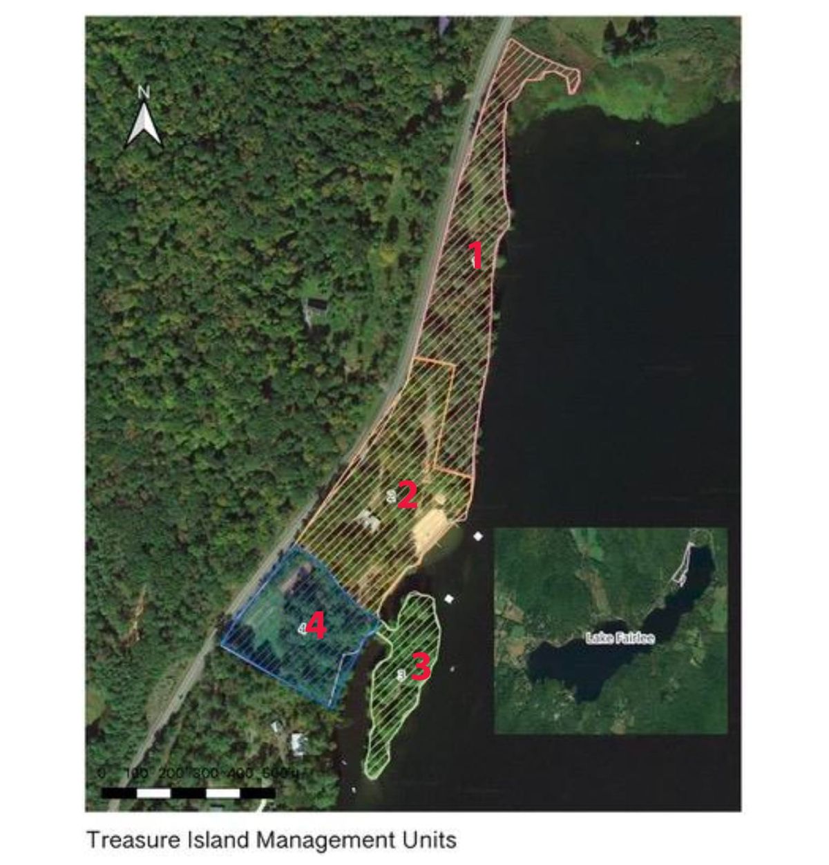
For clarity and planning purposes, Treasure Island has been divided into four Management Units (MUs). Each Management Unit was delineated based on habitat type, uses, and physical features.
MU1 is the northern-most block. This area requires restoration but it will remain the least developed section of the park. To the north, MU1 extends into a shrubby wetland that surrounds the outlet of Blood Brook. This MU extends south to the entrance road and includes a narrow strip of shore along the edge of the parking area.
MU1 is characterized by shrubby wetland, transitioning to an upland forest with pockets of wet seeps and a wet meadow. The forest canopy is quite open with gaps from dead trees, beaver activity, the wet meadow, the road, and the lake.The large-diameter white pine found here provide excellent habitat diversity as growing stock, standing snags, and forest floor woody debris. Sugar maple, American beech, ash, and oak are scattered throughout the MU. Understory trees such as dogwood and serviceberry occur in the edge habitat. Toward the southern end of MU1 the slope increases, rock outcrops are present, and the percentage of hemlock is greater.
For management, a “do-nothing, let it be messy” approach to the forest is very desirable. Allowing the chaos and messiness of nature to flourish in this area provides excellent forest habitat for a wide variety of terrestrial and aquatic organisms.
The wet meadow in MU1 is slowly giving way to alder shrubs, white pine and some black ash. Old fields such as this offer a habitat type that is lacking around Lake Fairlee. It should be maintained by brush hogging on a three-year cycle. Shrub habitat near water is preferred by grouse, American woodcock, rabbits, and other small mammals. An open meadow will favor wildflowers and pollinators
An unmaintained trail on MU1 follows the shoreline. It may owe its continued existence to exploring visitors. Its location at the edge of the lake is less than ideal. Compacted soils and trampled vegetation are detrimental to lakeshore habitat and invite erosion. A decision to re-route the trail or to dissolve it needs to be determined. If the trail is to be kept, it should be relocated away from the shore, the natural duff layer should remain intact, and access to the lakeshore limited to defined areas that are naturally armored with bedrock.
MU2 is the most developed area of the park. It slopes down from the road on an eastern aspect to a narrow flat area, mostly mowed, abutting the beach. It includes the parking area, most of the buildings, the beach, and associated recreational areas such as the playground, basketball/pickle ball court, and volleyball area. The southern boundary of MU2 is the road skirting the south side of the basketball courts. A forested area near Rt. 244 and the main house provides shade, absorbs stormwater and enhances the rustic feel of Treasure Island. The majority of this Unit is dedicated to recreation. The duff layer is mostly absent, and the soils appear compacted. As such, erosion was observed from stormwater moving across the parking area. Runoff from the beach and volleyball courts is transporting silt and sand into the lake.
Action items include installing rain gardens and stormwater diversions to trap runoff and prevent sediment from entering the lake. In addition the shoreline buffer of native vegetation should be restored, the oversized parking area should be scaled back, and sand eroding from the volleyball court needs to be retained.
MU3 is the area known as Treasure Island. It’s not technically an island, as it is attached to the mainland by a causeway. MU3 is heavily used and will require restoration to achieve a balance between human use, protection of water quality, and ecological benefits to the lake.
MU3 is a wonderful hemlock, pine, and oak forest that is being loved to death. Currently the overstory trees provide shade, but the forest floor, understory and mid-story have largely been stripped. The first step to restoring the Island area is to determine appropriate use.
Could the clearing be smaller and still be effective? The outhouses are redundant and may be scheduled for removal, an important step to protecting clean lake water. The old barbeque grills should be rebuilt and repositioned to concentrate visitors in a few areas. The areas where it is appropriate for people to gather should be defined by installing edging and limiting clean-up to those areas rather than mowing the whole area and stripping the natural duff.
A large mowed area abuts the causeway. It was once used to launch boats into a mucky cove that is a likely fish breeding site. There are better boat launches. The area could be allowed to revert to native vegetation, which would help trap sediment from stormwater flowing down the access road.
MU4 is the southernmost unit. It is an underutilized area appropriate for rustic recreational use. The area is partially forested with a healthy understory and thick duff layer. An overgrown trail begins near the basketball court, crosses a drainage, winds through woods and up a rocky area into the meadow. This trail is nicely located away from the shoreline and passes through several interesting habitat types. There is a framed platform that could be covered to provide a natural classroom or picnic area.
Closer to Rt. 244 is an open area that comprises meadow, clay tennis court, and septic system. The meadow has recreational potential. It could be mowed regularly during the summer to allow events, larger group gatherings, or just a play area.
All of the MUs have some degree of invasive plants, mostly honeysuckle and barberry. It is fortunate that there are only a few sites where they are established and that the colonies are small and still controllable by manual removal. Stewardship of the Treasure Island property should include regular inventories to identify any other areas of invasive plants.
Summary
The true challenge will be balancing the ecological need for habitat, clean water, and a healthy lake with human use of the property. By identifying Management Units that have different focus areas we can begin to balance competing uses for the property. With careful planning many of the activities that will benefit the lakeshore also improve the aesthetics of the property and enhance the user experience.